Button CopyPathCircle CloseCircle Left ArrowArrow Down Icon GreyClosecirclecircleBurger
  • Advertising

LOTS 5 & 6 20TH AVENUE, Hazelton, British Columbia, V0J 2J1

MLS® # R3045317
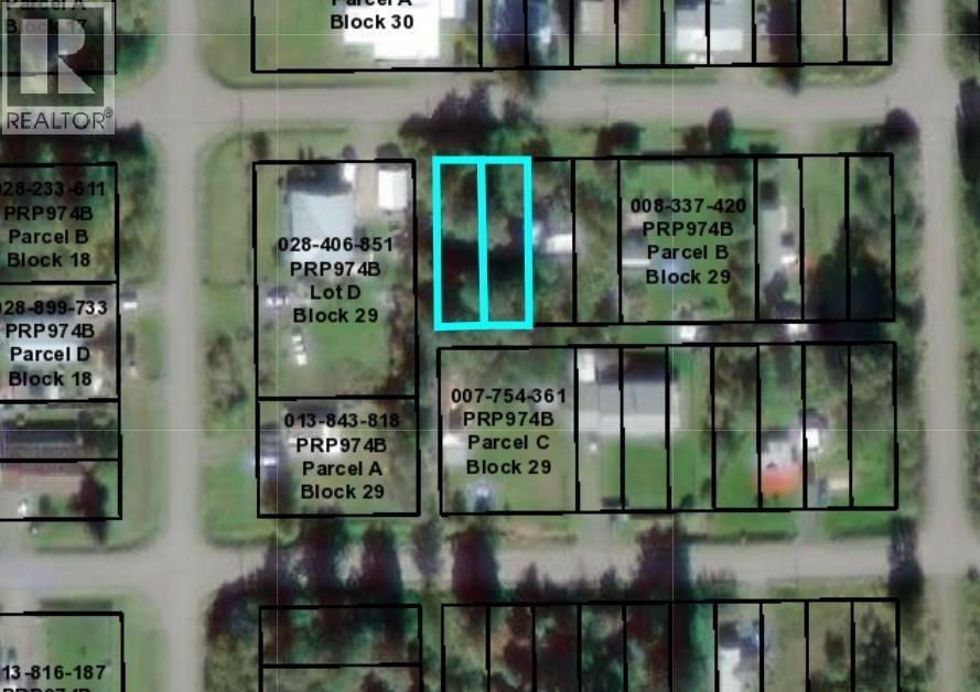
Vacant Land For Sale In Hazelton, British Columbia
$24,000

None Beds

Lots 5 & 6 20Th Avenue, Hazelton, BC
  • Advertising
LOTS 5 & 6 20TH AVENUE, Hazelton, British Columbia, V0J 2J1
$24,000

Property Information:

7,920 sq ft lot located in a quiet location in scenic South Hazelton. Zoned residential. Lot is level and treed. Water and Hydro close by. (id:27)

Building Features:

  • Construction Style - Attachment: Unknown

Property Features:

  • OwnershipType: Freehold
  • Property Type: Vacant Land
  • Lot Size: 7920.00 Square Feet
  • View Type: View

Courtesy of: RE/MAX Bulkley Valley

REALTOR.ca  

Location of LOTS 5 & 6 20TH AVENUE, Hazelton, British Columbia, V0J 2J1

Climate Risk Data

About Climate Risk: Properties are at increased risk of damage from extreme weather due to climate change.
ClimateCheck provides detailed climate risk data for properties now and up to 30 years into the future.

Projected Heat Risk: Moderate-Low

21 hot days expected in 2050

Projected Precipitation Risk: Moderate

16 storms expected in 2050

Projected Heat Risk: Moderate-Low

21 hot days expected in 2050

23/100

Moderate-Low

ClimateCheck®

Current data

This property, LOTS 5 & 6 20TH AVENUE , experiences 7 hot days per year at around 26.9 degrees Celsius.

Projected data

Severe heat risk is expected to increase in this area. In 2050, it is projected that there will be 21 hot days at 30 degrees Celsius.

Projected Avg. Temperature

Past
26.9℃
2050
30℃

# Hot Days Per Year

Past
7
2050
21

About Heat Risk

Heat risk is the number of extreme heat days experienced each year looking at historical conditions (1980-2005) in your area and taking the 2% of the hottest days and projecting that into the future.

Projected Precipitation Risk: Moderate

16 storms expected in 2050

59/100

Moderate

ClimateCheck®

Current data

This property, LOTS 5 & 6 20TH AVENUE , experiences 13 significant 2-day storms per year, with about 250mm of precipitation per storm.

Projected data

Severe storms are expected to increase in this area. In 2050, it is projected that there will be 16 significant 2-day storms with 310.5mm of precipitation per year.

Precipitation Per Storm

Past
250mm
2050
310.5mm

48-Hour Storms Per Year

Past
13
2050
16

About Storm Risk

Storm risk is the number of high wind, wet or snowy events each year. Climate check looks at historical conditions (1980-2005) in your area, on the days with the top 1% of total precipitation in a year and projected to 2050.

Climate risk data is provided for informational purposes only on Royallepage.ca.
If you have questions or feedback about this data, get help at climatecheck.com.

Environmental Risks provided by ClimateCheck®

Royal LePage does not endorse nor guarantee this information. By providing this information, Royal LePage and its agents are not providing advice or guidance on climate risks. Royal LePage strongly recommends that consumers independently investigate the property’s climate risks to their own personal satisfaction.

Demographic Information of LOTS 5 & 6 20TH AVENUE, Hazelton, British Columbia, V0J 2J1

Life Stage

Midlife Families

Employment Type

Blue Collar/Primary, Blue Collar/Service Sector

Average Household Income

$88,000.00

Average Number of Children

1.90

Household Population

Household Structure

Age of Population

Education

Education Level

No certificate/diploma/degree

38.6 %

High school certificate or equivalent

29.82 %

Apprenticeship trade certificate/diploma

8.77 %

College/non-university certificate

14.03 %

University Degree

8.77 %

Commuter

Travel To Work

By Car

83.34 %

By Public Transit

8.33 %

By Walking

0.0 %

By Bicycle

0.0 %

By Other Methods

8.33 %

Cultural Diversity

Knowledge of Official Language

Mother Tongue

Building Information

Building Type

Apartments (Low and High Rise)

Houses

100.0 %

Own Vs. Rent