Button CopyPathCircle CloseCircle Left ArrowArrow Down Icon GreyClosecirclecircleBurger

16904-18 HIGHWAY 7 Highway, Perth, ON, K7H 3C8

MLS® # 1358938
Vacant Land For Sale In Perth, Ontario
$2,100,000
16904-18 Highway 7 Highway, Perth, ON
  • Advertising
ACTIVE
16904-18 HIGHWAY 7 Highway, Perth, ON, K7H 3C8
$2,100,000

Property Information:

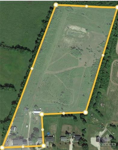
Here's an opportunity to develop a mixed use residential (zoned R4) property just 1 KM east of the town of Perth. Take advantage of all the amenities Perth has to offer by building immediatley next to its neighbouring township. This 15.594 acre lot currenlty established with a multi-residential 6 unit and 2 single dweling properties fronting the highway and are being sold "where-is, as-is" ready for your development plans -the brown bungalow fronting the highway is perfect for a site office along with a steel shed with a garage door for equipment storage. The second parcel at 16918 is single dwelling without power or utilities and is also being sold "as-is, where-is" and measures .442acres. The land is level and dry, there is no surface water on the property. There is also an older environmental study for the 16904 parcel which indicated the property as clean. 24 Hrs irrevocable please.*** All persons wishing to access to the property must be be accompanied by a Realtor ***

Property Features:

  • Annual Tax Amount: $3,232
  • Irregular: Yes
  • Lot Depth: 349.61
  • Lot Improvements: Other Outbuilding
  • Neighbourhood Influences: Golf Nearby, Highspeed Available, Paved Road, Shopping Nearby
  • Road Access: Highway
  • Road Surface: Asphalt
  • Sewer Type: Septic Installed
  • Site Influences: Acreage, Flat Site, Hydro, No Rear Neighbours, No Thru Road
  • Zoning: R4
  • Zoning Code City Of Ottawa: RESIDENTIAL - Residential Fourth Density (4)
  • Water Supply: Drilled Well

Data provided by: Ottawa Real Estate Board 1826 Woodward Drive, Ottawa, Ontario K2C 0P7
All information displayed is believed to be accurate but is not guaranteed and should be independently verified. No warranties or representations are made of any kind. Copyright© 2021 All Rights Reserved

Location of 16904-18 HIGHWAY 7 Highway, Perth, ON, K7H 3C8

Climate Risk Data

About Climate Risk: Properties are at increased risk of damage from extreme weather due to climate change.
ClimateCheck provides detailed climate risk data for properties now and up to 30 years into the future.

Projected Heat Risk: High

32 hot days expected in 2050

Projected Storm Risk: Very High

14 storms expected in 2050

Projected Heat Risk: High

32 hot days expected in 2050

51/100

High

ClimateCheck®

Current data

This property, 16904-18 HIGHWAY 7 Highway , experiences 7 hot days per year at around 31.1 degrees Celsius.

Projected data

Severe heat risk is expected to increase in this area. In 2050, it is projected that there will be 32 hot days at 34.6 degrees Celsius.

Projected Avg. Temperature

Past
31.1℃
2050
34.6℃

# Hot Days Per Year

Past
7
2050
32

About Heat Risk

Heat risk is the number of extreme heat days experienced each year looking at historical conditions (1980-2005) in your area and taking the 2% of the hottest days and projecting that into the future.

Projected Storm Risk:

14 storms expected in 2050

61/100

ClimateCheck®

Current data

This property, 16904-18 HIGHWAY 7 Highway , experiences 11 significant 2-day storms per year, with about 306.1mm of precipitation per storm.

Projected data

Severe storms are expected to increase in this area. In 2050, it is projected that there will be 14 significant 2-day storms with 385.4mm of precipitation per year.

Precipitation Per Storm

Past
306.1mm
2050
385.4mm

48-Hour Storms Per Year

Past
11
2050
14

About Storm Risk

Storm risk is the number of high wind, wet or snowy events each year. Climate check looks at historical conditions (1980-2005) in your area, on the days with the top 1% of total precipitation in a year and projected to 2050.

Climate risk data is provided for informational purposes only on Royallepage.ca.
If you have questions or feedback about this data, get help at climatecheck.com.

Environmental Risks provided by ClimateCheck®

Royal LePage does not endorse nor guarantee this information. By providing this information, Royal LePage and its agents are not providing advice or guidance on climate risks. Royal LePage strongly recommends that consumers independently investigate the property’s climate risks to their own personal satisfaction.

Demographic Information of 16904-18 HIGHWAY 7 Highway, Perth, ON, K7H 3C8

Life Stage

Midlife Families

Employment Type

Mixed

Average Household Income

$121,555.77

Average Number of Children

1.70

Household Population

Household Structure

Age of Population

Education

Education Level

No certificate/diploma/degree

8.48 %

High school certificate or equivalent

30.44 %

Apprenticeship trade certificate/diploma

6.23 %

College/non-university certificate

29.96 %

University certificate (below bachelor)

1.67 %

University Degree

21.66 %

Commuter

Travel To Work

By Car

90.22 %

By Public Transit

0.0 %

By Walking

8.2 %

By Bicycle

0.57 %

By Other Methods

1.01 %

Cultural Diversity

Knowledge of Official Language

Mother Tongue

Building Information

Building Type

Apartments (Low and High Rise)

11.73 %

Houses

86.58 %

Own Vs. Rent