Button CopyPathCircle CloseCircle Left ArrowArrow Down Icon GreyClosecirclecircleBurger

Lot route 320 et 303, Anse-Bleue, New Brunswick, E8N 2B8

MLS® # NB094944
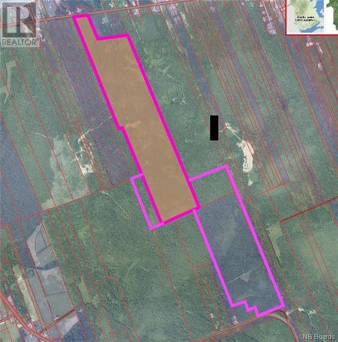
Vacant Land For Sale In Anse-Bleue, New Brunswick
$515,800
Lot Route 320 Et 303, Anse-Bleue, NB
  • Advertising
ACTIVE
Lot route 320 et 303, Anse-Bleue, New Brunswick, E8N 2B8
$515,800

Property Information:

The land has access to route 320 in Anse-Bleue as well as route 303 to Village-des-Poirier. It covers an area of ??257 acres, which is equivalent to approximately 104 hectares. It is a fairly large area that can offer many possibilities for different types of use. The land is mainly wooded, which can be an asset for those looking for a natural environment with mature trees. The woods can also provide opportunities for hunting, hiking, sustainability, or other recreational activities. A draft solar project that would bring in $50,000 per year for a lifespan of 50 years. Part of the land was previously used as a blueberry field. Can be used as agricultural/residential or even commercial land. (id:27)

Property Features:

  • OwnershipType: Freehold
  • Property Type: Vacant Land
  • Access Type: Year-round access
  • Features: Treed
  • Soil Type: Unknown
  • Structure Type:

REALTOR.ca  

Location of Lot route 320 et 303, Anse-Bleue, New Brunswick, E8N 2B8

Climate Risk Data

About Climate Risk: Properties are at increased risk of damage from extreme weather due to climate change.
ClimateCheck provides detailed climate risk data for properties now and up to 30 years into the future.

Projected Heat Risk: Significant

27 hot days expected in 2050

Projected Storm Risk: Very High

15 storms expected in 2050

Projected Heat Risk: Significant

27 hot days expected in 2050

32/100

Significant

ClimateCheck®

Current data

This property, Lot route 320 et 303 , experiences 7 hot days per year at around 28.5 degrees Celsius.

Projected data

Severe heat risk is expected to increase in this area. In 2050, it is projected that there will be 27 hot days at 31.6 degrees Celsius.

Projected Avg. Temperature

Past
28.5℃
2050
31.6℃

# Hot Days Per Year

Past
7
2050
27

About Heat Risk

Heat risk is the number of extreme heat days experienced each year looking at historical conditions (1980-2005) in your area and taking the 2% of the hottest days and projecting that into the future.

Projected Storm Risk:

15 storms expected in 2050

77/100

ClimateCheck®

Current data

This property, Lot route 320 et 303 , experiences 11 significant 2-day storms per year, with about 365.4mm of precipitation per storm.

Projected data

Severe storms are expected to increase in this area. In 2050, it is projected that there will be 15 significant 2-day storms with 482.8mm of precipitation per year.

Precipitation Per Storm

Past
365.4mm
2050
482.8mm

48-Hour Storms Per Year

Past
11
2050
15

About Storm Risk

Storm risk is the number of high wind, wet or snowy events each year. Climate check looks at historical conditions (1980-2005) in your area, on the days with the top 1% of total precipitation in a year and projected to 2050.

Climate risk data is provided for informational purposes only on Royallepage.ca.
If you have questions or feedback about this data, get help at climatecheck.com.

Environmental Risks provided by ClimateCheck®

Royal LePage does not endorse nor guarantee this information. By providing this information, Royal LePage and its agents are not providing advice or guidance on climate risks. Royal LePage strongly recommends that consumers independently investigate the property’s climate risks to their own personal satisfaction.