Button CopyPathCircle CloseCircle Left ArrowArrow Down Icon GreyClosecirclecircleBurger

, Rathwell, Manitoba, R0G 1Z0

MLS® # 202403952
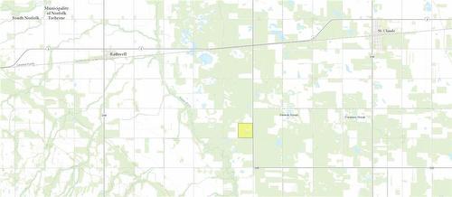
Vacant Land For Sale In Rathwell, Manitoba
$459,900
Rathwell, Manitoba
Rathwell, Manitoba
Rathwell, Manitoba
Rathwell, Manitoba
Rathwell, Manitoba
Rathwell, Manitoba
Rathwell, Manitoba
Rathwell, Manitoba
  • Advertising
ACTIVE
, Rathwell, Manitoba, R0G 1Z0
$459,900

Property Information:

R39//Rathwell/Approximately 158 acres of grain and pasture land. 70 acres pf grain land that was sewn into canola last year and 88 acre of pasture land, all 2 strand electric fenced with solar panels and fencer. Dugout on pasture land. If your looking for more land with combined grain and pasture this is it, for a tour of land or information call today (id:7525)

Building Features:

  • Building Type: No Building

Property Features:

  • OwnershipType: Freehold
  • Property Type: Vacant Land
  • Farm Type: Unknown

REALTOR.ca  

Location of , Rathwell, Manitoba, R0G 1Z0

Climate Risk Data

About Climate Risk: Properties are at increased risk of damage from extreme weather due to climate change.
ClimateCheck provides detailed climate risk data for properties now and up to 30 years into the future.

Projected Heat Risk: High

27 hot days expected in 2050

Projected Storm Risk: Significant

11 storms expected in 2050

Projected Heat Risk: High

27 hot days expected in 2050

46/100

High

ClimateCheck®

Current data

This property, , experiences 7 hot days per year at around 32 degrees Celsius.

Projected data

Severe heat risk is expected to increase in this area. In 2050, it is projected that there will be 27 hot days at 35.7 degrees Celsius.

Projected Avg. Temperature

Past
32℃
2050
35.7℃

# Hot Days Per Year

Past
7
2050
27

About Heat Risk

Heat risk is the number of extreme heat days experienced each year looking at historical conditions (1980-2005) in your area and taking the 2% of the hottest days and projecting that into the future.

Projected Storm Risk: Significant

11 storms expected in 2050

30/100

Significant

ClimateCheck®

Current data

This property, , experiences 10 significant 2-day storms per year, with about 225.6mm of precipitation per storm.

Projected data

Severe storms are expected to increase in this area. In 2050, it is projected that there will be 11 significant 2-day storms with 244.6mm of precipitation per year.

Precipitation Per Storm

Past
225.6mm
2050
244.6mm

48-Hour Storms Per Year

Past
10
2050
11

About Storm Risk

Storm risk is the number of high wind, wet or snowy events each year. Climate check looks at historical conditions (1980-2005) in your area, on the days with the top 1% of total precipitation in a year and projected to 2050.

Climate risk data is provided for informational purposes only on Royallepage.ca.
If you have questions or feedback about this data, get help at climatecheck.com.

Environmental Risks provided by ClimateCheck®

Royal LePage does not endorse nor guarantee this information. By providing this information, Royal LePage and its agents are not providing advice or guidance on climate risks. Royal LePage strongly recommends that consumers independently investigate the property’s climate risks to their own personal satisfaction.

Demographic Information of , Rathwell, Manitoba, R0G 1Z0

Life Stage

Families with Tweens

Employment Type

Blue Collar/Primary, Blue Collar/Service Sector

Average Household Income

$96,000.00

Average Number of Children

2.20

Household Population

Household Structure

Age of Population

Education

Education Level

No certificate/diploma/degree

25.35 %

High school certificate or equivalent

35.21 %

Apprenticeship trade certificate/diploma

9.86 %

College/non-university certificate

15.49 %

University Degree

14.09 %

Commuter

Travel To Work

By Car

100.0 %

By Public Transit

0.0 %

By Walking

0.0 %

By Bicycle

0.0 %

By Other Methods

0.0 %

Cultural Diversity

Knowledge of Official Language

Mother Tongue

Building Information

Building Type

Apartments (Low and High Rise)

Houses

100.0 %

Own Vs. Rent